Dr. Phillip Schmutz Studies Beach, Coastal Changes
Pensacola – Dr. Phillip Schmutz is an assistant professor in the University of West Florida’s Department of Earth and Environmental Sciences. Schmutz studies geomorphology, and he and his students survey the beach and dune systems to measure how they change over time.
Q: How did you initially become interested in studying coastal, beach and aeolian geomorphology?
Schmutz: My general interest in science and nature began as a child through my grandfather. He always had National Geographic, Science and Smithsonian magazines around his house. Because of this, I dreamed to be a college professor or at least wanted to do the things I read about in the magazines.
It wasn’t until college, however, that I became aware of the field of coastal geomorphology. I took coastal zone management my sophomore year and found the course material very intriguing. That course sparked my interest in coastal/beach systems.
However, it was the following summer when I spent a month on the island of Dominica in the Caribbean studying its beaches that I fell in love. I took the data collected from that summer course and turned it into my senior thesis, which involved updating beach surveys from the 1970s and ’80s.
I presented this research at regional and national conferences during my senior year, which provided the opportunity to meet prominent researchers in the field of coastal, beach and aeolian geomorphology. Through this process, I applied to a number of graduate schools eventually choosing Louisiana State University, where I received both my master’s and doctoral degrees.
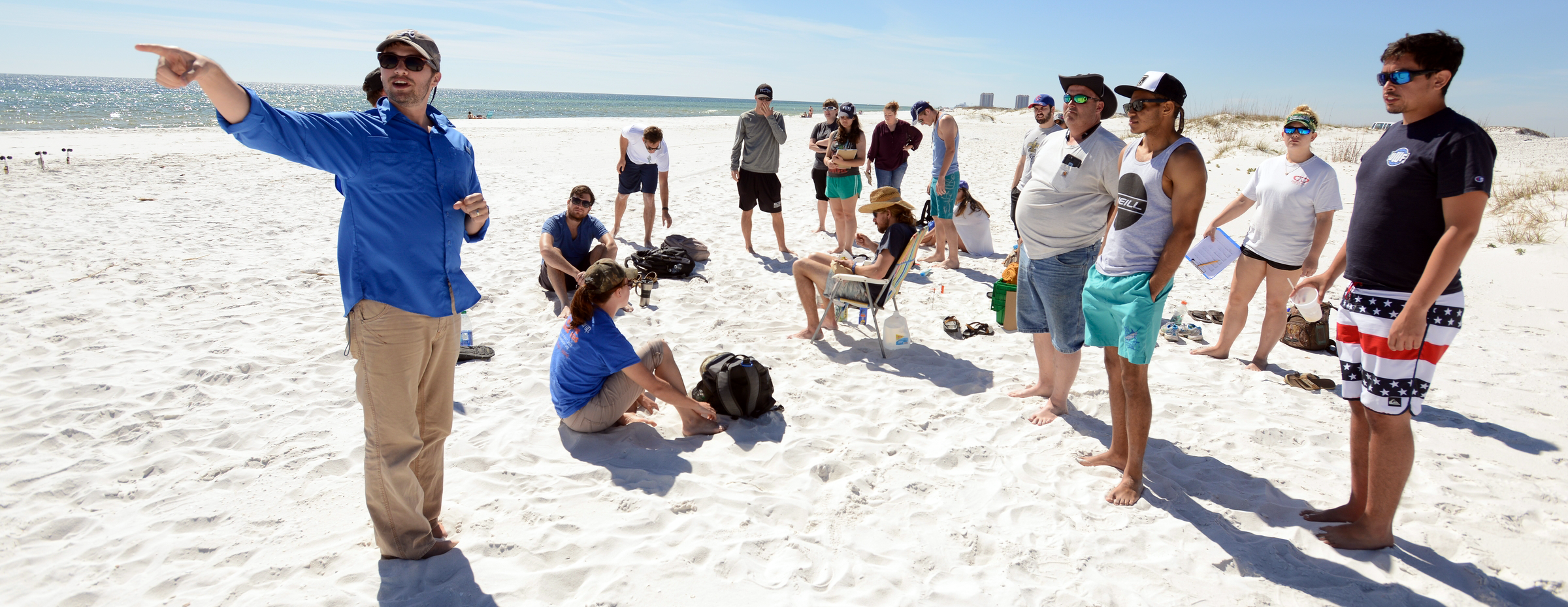
 Dr. Phillip Schmutz teaches students to use ranging poles while mapping.
Q: Your research involves the development of improved techniques to measure and model these environments. What are some of those approaches you have studied or incorporated?
Schmutz: This aspect of my research started during my master’s work. My research involved investigating the applicability and accuracy achieved by modifying an electronic soil moisture sensor to measure beach moisture content at very shallow surface depths.
These devices allow for quick and non-destructive measurement of moisture content.
However, the sensor lengths exceed the desirable few millimeters depth to capture “surface” moisture, thus the need to modify the devices.
For my doctoral dissertation research, I sought to improve our ability to measure and model the spatial and temporal dynamics of beach surface moisture content. Previous studies detailing beach moisture dynamics were uncoupled, considering only the influence of a single parameter. In reality, however, the beach moisture system is controlled by complex coupled interactions between hydrological, meteorological and sedimentary parameters. My dissertation was the first and most comprehensive analysis of surface moisture variability in context of the full suite of processes that drive the system.
I am continuing this line of research at UWF with a new research project. My dissertation improved our understanding of the connection between the various parameters. However, I discovered that it is very difficult to govern which process controls moisture content at a particular location and time. This new research involves utilizing the unique isotopic signatures that develop between liquid and vapor water to address this issue. By analyzing the isotopic signatures, it is possible to ascertain the dominant/controlling moisture pathway that contributes water to (e.g., groundwater, precipitation) or removes water from (i.e., evaporative forcing) the sand surface. This is a forward-thinking approach to the utilization of this method.
Q: What does the surveying that you and your students do tell you about the beach and dune systems?
Schmutz: By surveying the beach and dune system throughout the year, we are able to understand how the systems change seasonally and evolve over time. In an ideal state, the beach system will maintain an annual equilibrium, yet will exhibit very different seasonal profiles responding to the differing wind and wave conditions. During the summer, calmer swell waves build up the beach as sand is pushed ashore. Whereas during the winter, higher energy storm waves will erode the beach. For the dune system, the surveys help to understand seasonal and annual growth patterns. We are not only interested in the volume growth or shape of the dunes but also how these dunes grow with respect to type and density of vegetation.
These surveys show the students the natural seasonal processes of the coastal environment while also highlighting how the coastal environment is changing through the years. In a world of changing environmental conditions, an understanding of how our beach and dune environments are responding to these modifications is paramount for accurate management plans.
 Dr. Phillip Schmutz teaches students to use a line level to document elevation while mapping.
Q: What are the various techniques you use to survey the beach?
Schmutz: There are a number of ways to survey the beach depending upon your research question or objective. The beach surveys with my students are primarily a teaching tool, so it requires a method that is relatively quick yet accurate. We use standard survey equipment: straight-line engineering level and stadia rod. There are more precise (Total Stations) and quicker (drones) instruments but these are expensive and not necessary for our research purposes. With a team of three students we can measure a section of the beach that is 200 feet wide by 120 feet long in about two hours. To measure vegetation within the dune system, we utilize a standard square quadrate to determine the vegetation species present and percent cover of those species.
Q: You’ve recently used a drone to assist your students in their efforts to map the beach. How have the results of the drone mapping exercise helped with their research?
Schmutz: My use of drones to survey the beach is in its infancy. At the time, it was primarily used to showcase to my class how drone technology can facilitate beach research. Drones are very popular right now, and the students loved it.
I am working with folks at Remote Axcess (a local drone operator) to obtain sophisticated imaging equipment, which will provide the ability to generate innovative research. The advantage of drones in conducting geomorphology research is their ability to collect measurements over a large area quickly. As with the beach surveys, this will give us an understanding of seasonal and annual system changes but on a much larger scale and from a different perspective.
Excerpts from the Experts is a monthly feature that highlights research conducted by UWF faculty.
Most read in Life Science
-
Research Highlighted at UWF Student Scholars Symposium
Apr. 21, 2016 -

-